Even with a large US military presence, a considerable amount economic aid and weapons sales to “friendly” regimes, maintaining stability in the Middle East has proven to be a challenge.
A better understanding of the political geography of the Middle East can help us better answer why Middle East suffers from what seems to be chronic instability.
The Middle East is among the most strategically located regions in the world. Historically, it has been a continental junction, connecting Africa, Asia, and Europe. Since early 20th Century, the discovery of oil has made the region of primary importance to the rest of the world and in particular the U.S. and Europe. Maintaining political stability, to ensure an uninterrupted flow of oil, was first a priority of the British Empire and, after the end of the Second World War, the United States.
Unstable states equals unstable region
Regional instability is, in great part, the product of unstable states. These unstable states are partially the result of geography but are also, in no small part, manmade. The arid and mountainous geography of the region has favored the development of local tribal loyalties above national cohesion. In additional to these natural barriers, the artificial boundaries, drawn to serve the imperial interests of the British and the French, promoted even more profoundly unstable states by failing to reflect any of the local histories, peoples, languages, religions, or cultures.
Aridity sustains nomadism and the accompanying local tribal loyalties. The most arid regions, the deserts of the Middle East, are formidable barriers to national cohesion as well regional integration.
The largest of these deserts is the Sahara in North Africa. With an area the size of continental US it restricts East-West as well as North-South movement. Rub al Khali (The Empty Quarter) in Saudi Arabia is the second largest desert in the Middle East. It extends South East-North West, creating a wide gap between inside Saudi Arabia that separates the Shia population who live closer to Persian Gulf and the Sunni population who resides along the Red Sea. Rub al Khali also splits the region into two separate parts with Yemen, Oman on one side and Jordan, Israel, and Syria on the other.
Mountains are also major barriers to national and regional integration because, they too limit travel and trade while simultaneously facilitate defense of tribal or minority regions, core areas from which antigovernment challenges originate.
In the north east, the Caucuses and the Alborz constitute a thousand mile chain of mountains that straddles the Caspian Sea and is crowned with the 18000 feet high Mount Damavand in northern Iran. These two mountain ranges restrict travel in the North-South direction. The Zagros Mountains stretch for more than 500 miles in a north-south direction in western Iran with several peaks reaching above 13000 feet. It hinders West-East travel. In addition, mountain ranges crisscross the Kurdish plateau and Mount Ararat in eastern Turkey reaches to nearly 17000 feet high.
Regional instability is, in part, the product of artificial boundaries

The geometric boundaries of most Middle East states, a thousand miles of which are straight lines, were drawn around the turn of the 20th Century, by European powers in order to serve their imperial interests rather than to reflect any of the local histories, peoples, languages, religions, or cultures. These European interests were oil, trade, trade, and containment of Soviet Union, interests that have been remarkably similar to those of the United States since the end of the Second World War.
The result has been creation of states that are internally divided while at the same time pulled away by kinships across their frontiers.
http://thedailyshow.cc.com/videos/kovgs5/sir-archibald-mapsalot-iii
Iraq, for example, is divided along Arab and Kurdish as well as Shia and Sunni regions. The north is Sunni – Kurd, the Center Arab – Sunni, and the South Arab – Shia.
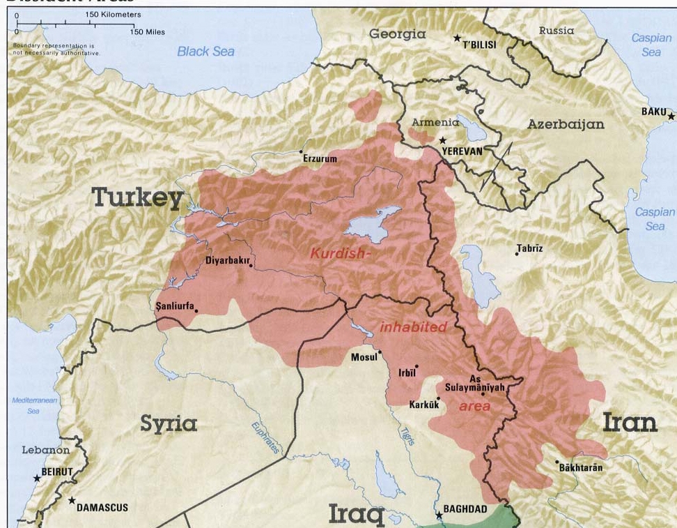 For the Kurds in northern Iraq, their kin who live across international borders in Syria, Turkey, and Iran pull them away from the rest of Iraq. Protected by mountains Kurds have denied these states complete control over their homeland.
 In the south, the Shia Arabs find their kin across the border in Saudi Arabia and Kuwait while the Sunni – Arab region in the center extend westward deep into Syria.
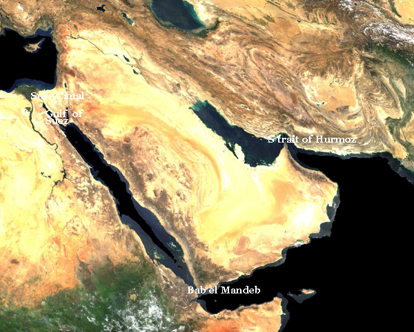
Regional instability has direct effect on oil export due to narrow maritime chock points
The most important of these narrow passages is the Strait of Hormuz. It connects Persian Gulf to the Indian Ocean via the Gulf of Oman and the Arabian Sea. Strait of Hormuz is only 21 miles wide but through it moves 20% of all traded oil worldwide.
On their way to Europe, oil tankers must travel through additional chock points; the Bab el-Mandeb Strait that links the Red Sea to the Gulf of Aden and the Indian Ocean and further north the Gulf of Suez and Suez Canal. Bab el Mandeb is only 20 miles wide. Similarly, the Gulf of Suez is only12 to 20 miles wide and the Suez Canal is a mere 673 feet wide.